If you are standing on the ground in the Quiet Corner, you are probably also standing on top of a valuable hidden resource - groundwater. There is a hundred times more water in the ground than in all the worlds’ rivers and lakes combined.
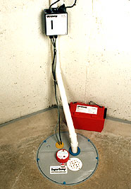 |
A reliable sump pump can prevent basement flooding. A battery backup sump pump is a wise investment in case of power losses which are common during severe storms. |
Groundwater is the water that percolates through the land and fills in the tiny empty spaces between soil particles or cracks in rocks. Eventually it hits a layer that is too dense to easily seep through. This confining layer may be rock or clay. An underground reservoir that contains a usable supply of water in soil or rock voids is called an “aquifer.” Aquifers in our area are generally made up of sand, gravel, or fractured rock like schist or gneiss.
To tap into an aquifer, wells are dug or drilled until they reach the top layer of the water. 2.3 million people in New England get their water from their own private well (Source: EPA). Nationwide, about 21% of water for all uses like drinking, household use and irrigation comes from groundwater. In rural areas, that number might be as high 95% for drinking water. (Source: USGS). The average American uses 100 gallons of water a day. (Source: EPA).
The top of the water surface in the saturated zone of the soil is called the “water table.” The water table is neither flat nor stable. Instead, it roughly follows the contour of the land above it. When we get a lot of rain in a short period of time, the water table fluctuates. As pores in the soil get saturated with liquid, the water table rises up or moves sideways because it has nowhere else to go. Since water follows the path of least resistance, when the water table is high, it may also end up moving through cracks in the walls or stone foundation of your basement. During the winter, you might see water seeping out of cracks in the rock along a road cut, where it turns into a frozen waterfall. Sometimes an aquifer pops out of the side of a hill as a “spring.”
In Northeastern CT, we get an average of 43.8 inches of precipitation (rain, snow, hail etc.) a year. (Source: World Climate, 1961-1990). Water tables usually peak in the winter and spring as the snow melts and we get heavy rains. In the summer, the groundwater level usually sinks lower as a result of evaporation, uptake by plants. and pumping for irrigation. The water table typically hits its lowest point in early fall. Then it gets recharged by rainfall and accumulated water from places like swamps and lakes, unless runoff from impervious surfaces like pavement takes it away.
Activity for Kids: You’ll need water, two sponges, and piece of plastic wrap. Take the two dry sponges and lay one on top of the other in the sink. To simulate rainwater, pour water on the top. Watch the water seep through the top sponge down into the bottom sponge. If you stop adding water, the top sponge will eventually dry up, and as water drips out of the bottom sponge, it will dry up too.
Next put a piece of plastic wrap between the two sponges, creating a “confining layer.” Now when you pour water on the top sponge, the water will seep down until it hits the plastic wrap, which it can not flow through. The top sponge will get saturated, and then the water will start flowing sideways and come out the edges of the sponge. Hopefully this experiment does not simulate what happens in your basement every time we get a Nor’Easter. |